In the middle part of Mácha's region rise the Housecké hills. The highest peak of which is Vrátenská Mountain (508m). A new lookout tower has been built on this mountain top. There used to be one here in the olden times when tourism was in its beginnings. Okrašlovací Spolek in Mšeno (Embellishment Organization in Mšeno) received an old fire tower in 1893. They took it to pieces and rebuilt it on the peak of Vrátenka. But the upkeep was difficult and so they dedicated it to the KČT (Czech Tourist Club), however they also did not have enough finances to keep it in tact and so the tower collapsed in 1903. The new one, built by an Austrio-Czech firm is much more substantial. It cost 8 million crowns. The building was financed by Sdružení obcí Kokořínska (Association of Municipalities of the Kokořínsko Region) together with the entrepreneurs of radio-communication networks and this is one of the few examples of rational co-operation in this direction in the republic, in contrast to other mountain peaks where giant broadcasting towers looking like gas towers stand next to old stone watch towers.
The Vrátenská lookout tower has an interesting triangle base, the staircase is sheathed, and after 126 steps you find 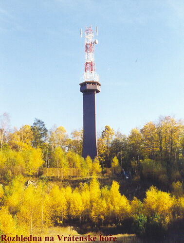 yourselves on a roofed platform in a height of 25 meters. The remaining of the 42 meter high tower is created by antenna constructions. The view is worth the climb. The whole of Mácha´s region, ruled by the double peaked Bezděz, is visible as if on the palm of one’s hand. The Ještěd broadcasting tower is also nicely visible, and a little further, Český Ráj (Bohemian Paradise) with Trosky Castle and, in addition when visibility is fine, then Krkonoše and Jizerské Mountains. On the other side, the Krušné Mountain ranges are also visible. The country beneath the tower is weaved by a dense network of tourist trails and footpaths and these have been taken fancy to by not only hikers but also a rising number of cyclists. Thus together with the building of the new lookout tower, a new cycle trail has been put together. The marking has been made according to the unified KČT (Czech Tourist Club) system by which all cycle trails in the republic shall eventually be marked. The signs of the terrain cycle trails are in essence the same as footpath marking, they only differ in the basic colors, the arrows and borderlines are yellow and the trails can thus be marked in four colors - red, green, blue and white. Beneath Vrátenská Mountain there lies a red marked fifteen kilometer trail which is intersected by green marking, leading you to the lookout tower.
If you cycle to Mělník via the road through Kokořínský důl (Kokořísnký valley) in the direction of Dubá, turn right at Ráj for  Mšeno and immediately turn left to Libovice. Both turnings have signposts marking out the route to the lookout tower. You shall reach the yellow braided red markers at Příbohy. Because this trail runs full circle, it doesn’t matter which direction you take. If you turn left, the wooded path slowly ascends to the Housecký hřeben (Housecký crest).
  Here it pays off to leave the trail for a while and take the red tourist footpath in order to visit the Houska chateau. After visiting this chateau return to the cycle trail and enjoy a fast downhill ride which shall gradually transform itself into a highly difficult ascent. You shall run onto the green trail for the first time at the Vojetín crossroads. This trail leads through Na Fučíkovském hamlet and ascends to Vrátenská hora (Mountain). The red trail leads on through Vojetín, a village lost in the forests, the romantic Kružský důl (valley) and carries on through sandstone cliffs all the way to the road leading to Nosálov. Nosálov is interesting for its best-preserved urban architecture in the whole area, but also for its famous pub where a tired cyclist can not only refresh himself but also eat to his heart’s content.
From Nosálov the trail rises into Libovice where there you shall arrive to the crossroads with the reverse end of the green trail which also leads to the lookout tower from here. The red trail carries on by a long descent via a road of low quality surface all the way to Příbohy, where the trail closes.