Mšeno, as charted on the map of the Czech Republic.
A newly published map of the town of Mšeno and its surroundings – one side containing a map of town, the other a tourist map of its closest environment. Sale starting 31.7. 2004 in the TIC (Tourist Info Center), also available at other points of sale.
 Interactive map of Mšeno and its surroundings
This double-faced tourist map (scaled 1:25 000) was published by a small publishing house ROSY, Rohlík&syn Mělník, in cooperation with the Protected Landscape Area Kokořínsko (CHKO Kokořínsko) and the Czech Tourist Club (KČT). Maps may be purchased in bookstores in Mělník, and Info Centers at the Kokořín and Houska castles, as well as in boarding houses and hotels. They are also available at the Mšeno TIC and the local tobacconist’s and newsagent’s. Volumes also come in laminated version. Published 2004.
Maps 1:50 000 are published by the Czech Tourist Club (KČT). The charts, based on a military – formerly confidential- material, cover all of the republic. The maps are in a nationwide distribution, available with booksellers, info centers etc.
General map of Mšeno’s surroundings
Chart of the Protected Landscape Area Kokořínsko (CHKO Kokořínsko)
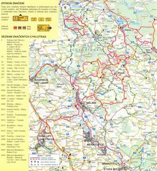
Map of cycle trails
Map of tourist footpaths
Digital map on pages of the Association of Municipalities of the Kokořínsko region.


